ISLAND AID Area of Operations
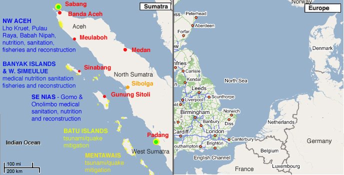
This map helps to understand the scale of the area ISLAND AID supported since the Great Tsunami of Dec 26th 2004.
The Blue text indicates areas we have supported with "Batavia" & "Electric Lamb" to date.
The yellow text indicates areas where we have only worked with smaller boats including "Electric Lamb"
Red cities have civilian airports. (Sibolga is a military airstrip)
Green cities are our preferred loading ports.
Yellow shaded areas are the areas we have either already supported or areas we know need support and are not getting any.
The only yellow area we can reach by commercial flight/ferry + vehicle is Gomo in SE Nias.
NW Aceh is serviced by a temporary road but it has deteriorated to the point where it is only passable after extended periods without rain. There is motorcycle access to West Simeulue but no 4 wheel vehicle access due to bridge damage. There are no roads on the Banyaks or Batus and only a few km of passable roads in the entire Mentawai chain.
The map of Europe is at the same scale......
ISLAND AID have proven how effective ship-borne aid can be and that is what we are determined to resume. Meanwhile we are busy in the Mentawai's using Lautan Megah and the Electric Lamb.
Island Aid is operated by The Electric Lamb Mission, a California public benefit corporation.
posted by Island Aid at Sunday, January 08, 2006
![]()
![]()


0 Comments:
Post a Comment
<< Home